Tucked among the trees at Pigeon River Country State Forest near Gaylord, you’ll find a handful of tiny turquoise gems. Read on for how to find these sublime sinkhole lakes and to see how stunning they are for yourself.
Looking for Up North road trips, insider tips, great restaurants and pristine beaches? Get your copy of Vacation! Northern Michigan and discover the best vacay ever.
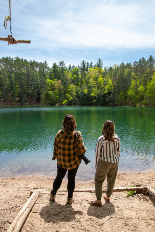
A few weeks ago, Allison Jarrell and I took off for Gaylord. Our mission: Get Lost. (Seriously!) We were heading to Lost Lake, one of seven sinkhole lakes in Northern Michigan’s Pigeon River Country State Forest that are open to the public. These small lakes are a beautiful spot to take a swim or float in a tube, but there are a few things you need to know before visiting.

Photo by Dave Weidner
Rudi Edel at the Pigeon River Country Discovery Center answers a few common questions:
What are Gaylord’s Sinkhole Lakes?
“A retired DNR geologist, Ty Black from the Roscommon area, told me those lakes were formed due to dissolving salts about 900 feet below the surface around 10,000 years ago. Because the lakes are not stream fed but water fills them from deep within the Earth, the water has a bluish green tint when viewed near noon (high sun).
“The first time I saw them, memories of the Caribbean flashed before my eyes. They average about 68 feet deep. Fishing is allowed, but you can only take one fish. From approximately 1948 to 1972, these lakes were restricted to the public because the DNR was conducting trout studies using them. They were ideal laboratories for the research project because the lakes are not fed fresh water from a stream or creek.”


Photo by Dave Weidner

Photo by Dave Weidner
How Do You Get to the Sinkhole Lakes?
“Every lake is accessible by vehicle [and a short hike]. To my surprise, each lake also has several geocaches by them. I was with three of my grandchildren when I learned this point!”
Find a map online at the Pigeon River Country Discovery Center website. The Gaylord Michigan Tourism Bureau website also has helpful information.

Photo by Dave Weidner
Directions to Lost Lake
Lost Lake: Twin Lakes Road, Corwith Township
Head north out of Gaylord toward Vanderbilt, then swing right and you’ll find yourself in the 109,000-acre Pigeon River Country State Forest, the largest block of contiguous undeveloped land in Michigan’s Lower Peninsula. You should expect to lose cell service out here in Michigan’s “Big Wild,” so pack a map and your sense of adventure. We visited Lost Lake (also called East Lost Lake; West Lost Lake is across the road).
Recreational Guidelines
The unique features of these sinkhole lakes require special protection. Please respect these guidelines: Section 4, Ford, Hemlock, and all four of the Lost and Twin Lakes are stocked annually with trout and operate under Type D regulations. Camping within 600 feet of the sinkhole lakes is prohibited. Both of the Twin Lakes, Section 4 and (East) Lost Lake don’t allow boats of any kind, although swimming and personal flotation tubes are permitted. On Hemlock Lake, Ford Lake and West Lost Lake, visitors can use non-motorized watercraft or boats with an electric motor.
Related Read: How to Avoid Swimmer’s Itch in Northern Michigan Lakes