

Looking for information on when and where to see wildflower blooms in Northern Michigan this spring? Be sure to check out these local resources for three essential wildflower hikes.
Grass River Natural Area
6500 Alden Hwy., Bellaire | Grass River Website
Bloom Charts: Before you go, check out Grass River’s self-guided flower walk pamphlets, complete with average bloom times for each species found in the area. The nonprofit has individual guides for each month, May through August, on its website. (Be sure to also check out their brand new May/June guide, which covers this year’s early bloom schedule, wildflower identification and bird songs.) For more updates, follow Grass River on Facebook.
Directions: The Grass River Natural Area entrance is off Alden Highway (Co. Road 618), four miles northeast of Alden, six miles south of Bellaire and eight miles west of Mancelona. The preserve is also accessible by boat from the Grass River dock located between Clam Lake and Lake Bellaire.

Photo by Allison Jarrell
Clay Cliffs Natural Area
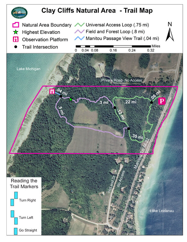
4755 N. Manitou Trail, Lake Leelanau | Clay Cliffs Website
List of Flora: For a comprehensive list of the types of flora you can find at Clay Cliffs Natural Area, check out this summary (spoiler alert: 163 native species can be spotted here!). More information on Clay Cliffs, including trail features and the history of the property, can be found on Leelanau Conservancy’s website. Follow the conservancy on Facebook for updates.
Directions: Clay Cliffs Natural Area is just over two miles north of Leland—the entrance is off of M-22. (View a map of the 1.5-mile trail system here.)

Photo by Allison Jarrell
Pete’s Woods Trail
7292 Swamp Rd., Arcadia | Pete’s Woods Website
Field Guide: Grand Traverse Regional Land Conservancy offers a comprehensive field guide focused solely on Pete’s Woods in Arcadia Dunes. The photo-illustrated guide identifies 32 different native plants, along with the seasons you can spot them and some fun facts about each one. You can find more info on Pete’s Woods and other GTRLC properties on their website, or follow them on Facebook.
Directions: From Arcadia: Take M-22 north for about three miles to Joyfield Road and turn right. After about 3.5 miles, turn right onto Swamp Road. The trail entrance will be on the right in about a quarter-mile. From Benzonia: Take US-31 south for 6.3 miles. Turn right onto Joyfield Road, and drive for 1.5 miles to Swamp Road. Turn left and drive for about a quarter-mile; the trail entrance will be on the right. (View a map of the 1.5-mile trail loop here.)

Photo by Allison Jarrell